
Reminder: There will be a public meeting to discuss the Stillwater River Road closure at the Nye Fire Hall on Thursday, July 30 at 6:30pm. All three Stillwater County Commissioners are expected to be in attendance.

Click on graphic to read full document
The Stillwater County Commissioners released two documents to the Billings Gazette yesterday that they will be presenting at the meeting. These include a “geotechnical reconnaissance” and risk assessment prepared by SK Geotechnical of Billings and received by the County Commissioners on June 15, and a preliminary proposal for rockfall remediation by Geostabilization International (GSI) of Grand Junction, CO, dated July 13. The two documents were prepared for Great West Engineering of Billings, which presumably is being considered as the contractor for the project. The two documents have been combined into one, and are a total of eight pages. I strongly recommend you read them if you are going to the meeting. You can download them by clicking on the graphic at right.
Key points from the risk assessment
The risk assessment includes two photos (pages 7 and 8) that highlight the situation as of June 15. Key points:
- “Numerous areas…appear to be unstable. In the vicinity of label 2 (see photos below), several suitcase-sized rocks were observed which appeared to be relatively loose. Outside of the immediate wedge failure area, other portions of the rock face appear to have a high risk of wedge failures in the future. Areas #9 and #10 have discontinuities that intersect to create a wedge. They appear to be relatively stable when compared to the loose rocks in area #2, but the risk of failure still exists. A large rock is defined by the discontinuity shown with lines labeled #7 and #8. These discontinuities represent failure planes, and although no active movement was observed, there is a risk of future failure.

As to the question of the amount of risk, the report is somewhat equivocal. It states that there is clearly risk, but “the rock face has always had a risk of failure and subsequent hazardous conditions. The risk of failure increases seasonally with the highest risk coming in the spring with heavy snow melt and spring rains. A seismic event (earthquake) is one of the highest risks for rock slides to occur along the rock face. It is our opinion the rock face is currently at a slightly higher risk of failure than it was one day before failure due to the visible seeps. When these seeps are no longer visible, then it is our opinion the risk of failure is basically the same as it was before the recent rock slide. Assuming some risk is acceptable, then it is our opinion the road can be cleared and opened when the visible seeps are no longer apparent.“
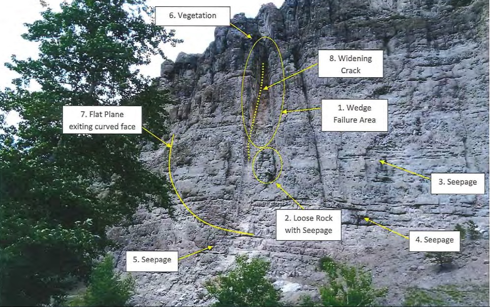 The question of risk should be a key area of discussion at the meeting.
Key points from the preliminary proposal
Scope of work
“The most critical portion of the slope is approximately 1/4 mile long, and can be separated into two remediation plans:
- The most dangerous part has loose rock, which can be mitigated by rock scaling to remove the loose rock.
- Installation of a temporary rockfall catchment system
A flexible rockfall barrier is recommended for the remaining 1/4 mile.
“It is further recommended that the rockfall remediation budget contain an allowance for rock dowel/deadbolt installation…to anchor rock formations that can not be removed safely with scaling techniques, but are too large to be arrested by the flexible rockfall barrier.”
Cost
The estimated cost of the proposal includes:
- Mobilization of the company $ 20,632
- Rock scaling to remove loose rock $322,061
- Rock bolt/dowels (30) $154,830
- Flexible rockfall barrier $999,557
Total $1,476,448
What is included in the cost estimate:
- Mobilization
- Manual scaling
- Rock bolt installation
- Flexible rockfall barrier
What is not included, and would presumably be the responsibility of the County:
- Traffic control
- Construction permits, if required
- Hauling of debris
- Construction surveying, if required
Timing
GSI indicates they can be on site within three weeks of signing a contract, and would do the work in one continuous effort. Scaling would take approximately 15 days.
GSI suggests the placement of the flexible rockfall barrier could be deferred until a later time, which would reduce the cost of the work by a million dollars.
As I understand this, that means that, once the County contracts with these companies, it would take three weeks to get to work, and another few weeks to do the work. The total short-term cost would be about $500,000.
***
This is just an overview. I recommend that you read the documents before the meeting. There is much to discuss.


Pingback: Posted in error | Preserve the Beartooth Front
Pingback: Update on Stillwater River Road rockslide | Preserve the Beartooth Front